November 2021 Webinar - Peatland Mapping from boreal to tropical zone in Americas
Thursday, November 18, 2021 (1:00 PM - 2:00 PM) (EST)
Description
Monthly webinars are offered as a benefit of membership. Once each quarter, in March, July, September and December, the monthly SWS webinar is open for non-members to attend (and at no cost), as well.
Peatland Mapping from Boreal to Tropical Zone in Americas
The webinar will be focused on research to map and monitor peatlands on the ground and from space to improve our understanding of peatland diversity, C-stores, vulnerability of these systems to land use change and Climate as well as emissions from fires and fire effects (in the boreal zone). The webinar will include description of techniques for peatland mapping from the boreal to tropical zone using multi-date imaging radar and optical-IR imagery in a machine learning classifier. Similar techniques and input imagery are used for boreal fens and bogs, tropical lowland pole forests and open fens as well as mountain cushion fens in tropical Andes with high accuracy. These often small systems can be missed with coarse resolution sensors, such as MODIS, and they are often grouped with another wetland type or missed altogether in global mapping projects. These techniques allow discrimination between peatland types to allow further analyses of vulnerabilities of a particular ecosystem type to climate and anthropogenic change. Background information on peatlands and effects of human land use development in the tropics and effects of increasing wildfire in the boreal zone will be covered. Mapping of burn severity in boreal peatlands, and other products based on Landsat and MODIS will be introduced as useful for detecting change in the peatlands and intersecting with the peatland maps to assess change
Presenter: Laura Bourgeau-Chavez, PhD Dr. Laura Bourgeau-Chavez is a senior research scientist at Michigan Tech Research Institute and an Adjunct Assistant Professor in the College of Forest Resources and Environmental Science (SFRES) of Michigan Technological University. She has a BS and MS from University of Michigan, School of Natural Resources and Environment as well as a PhD from University of New Brunswick, School of Forestry and Environmental Management. Her main interests are in using active microwave radar imaging with optical and lidar data for extracting moisture, inundation and biophysical information from wetland and upland landscapes. Her research includes targeted field campaigns to calibrate and validate remotely-sensed data and to better understand ecosystem function, Carbon storage/flux and disturbance effects in peatland and upland systems. Her research has been focused on understanding the effects of land use, wildfire disturbance and/or climate change on ecosystems in North American boreal-taiga regions, tropical lowland and mountain peatlands and the coastal Great Lakes. Her work has led to integration of microwave, lidar and optical sensing for mapping and monitoring wetlands/peatlands, forest soil moisture, forest biomass, invasive species and effects of land development and wildfire effect
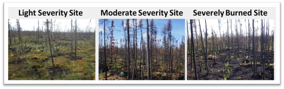 Three levels of burn severity to a boreal peatland with increasing consumption of the canopy and ground layers from light to severe burns.
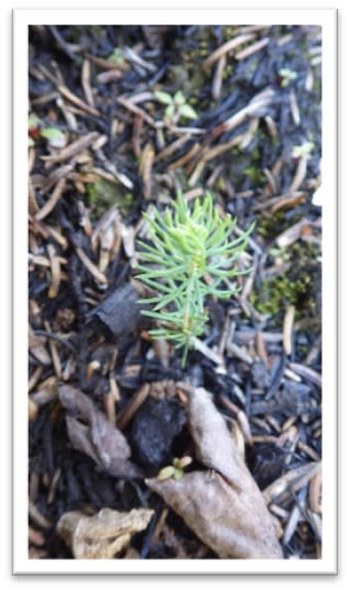
Small black spruce seedling regenerating in a peatland after fire.
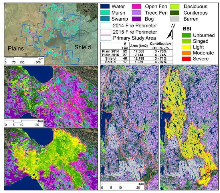
Maps of boreal peatlands and burn severity in Northwest Territories Canada. Displayed are maps of peatland types on the taiga plains and taiga shield and corresponding burn severity maps from 2014 wildfires.
26